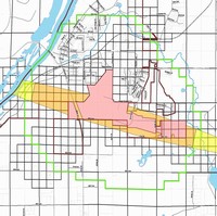

The Village Board has approved an Airport Overlay Zoning Ordinance on November 10, 2009.
The Airport Commission worked with MSA on the development of an airport overlay zoning ordinance. The purpose of the ordinance is to regulate the use of property within the designated vicinity of the L.O. Simenstad Airport in order to protect the approaches, airspace, and physical areas of the airport and to ensure the compatibility of the surrounding land uses and development to the greatest extent possible. Such regulations increase safety and reduce potential noise impacts associated with aircraft flying around the airport. Wisconsin statutes give the Airport the authority to regulate land use within 1.5 miles of the airport.
Attached is a copy of the proposed ordinance, a map of the airport, and a list of frequently asked questions.
Frequently Asked Questions about Airport Land Use Zoning
Airport Overlay Zoning Map
Chapter 69 Airport Code
